
Climate and science reporter
 Getty Images
Temperatures in the seas around the UK and Ireland have soared in the past week with some areas now 4C warmer than normal, with potential implications for marine life and people going swimming.
The heatwave is most intense off the west coast of Ireland as well as pockets off the coasts of Cornwall and Devon, according to scientists at the National Oceanography Centre and the Met Office.
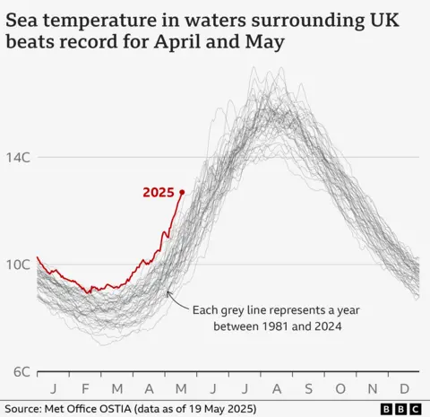
Sea temperatures in April and the first half of May were the highest recorded during those months since monitoring began 45 years ago.
Climate change is causing oceans to warm around the globe and is making marine heatwaves like this one more likely.
Scientists expect 2025 to be one of the hottest years on record for air temperatures.
“It’s super intense at the moment. The marine heatwave has really soared this week,” says Dr Ségolène Berthou at the Met Office.
Dr Zoe Jacobs, who is based at the National Oceanography Centre, first noticed the unusual marine temperatures a few weeks ago. She found that pockets of the UK had been coming in and out of a mild heatwave since late 2024. That heat intensified and spread in March and has now surged.
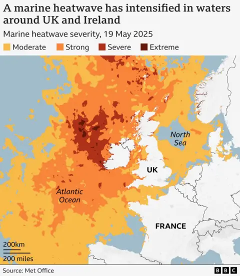
A marine heatwave is defined as sea temperatures that exceed the seasonal threshold for more than five consecutive days. In the UK the marine heatwave threshold for May is 11.3C.
On 19 May the average sea surface temperature reached 12.69C.
The entire west coast of the UK is now about 2.5C above average. A large portion of Scottish waters are 2-3C warmer than usual for the time of year.

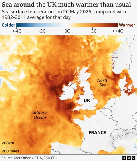
“It started in the North Sea and the Celtic Sea. Now the North Sea has cooled down a bit but the west of Ireland is extremely hot,” says Dr Barthou.
One of warmest Springs on record is driving the surge, as high temperatures and weak winds warm the top layer of the ocean.
Marine heatwaves in the UK are thought to be a relatively new phenomenon but they are expected to increase in frequency and intensity.
It is still a bit of a mystery how exactly they will affect marine life, but the signs so far are not good.
“The interesting thing is that this started in winter and spring, when most people assume marine heatwaves are only in summer,” says Dr Jacobs.
People swimming off the west coast of the UK and Ireland may notice the warmer temperatures, although the waters are still cooler than at their peak in late summer.
The worst impacts on species are likely to have been avoided for now because the temperatures have not gone above the upper limit that marine life can tolerate, explains Dr Jacobs.
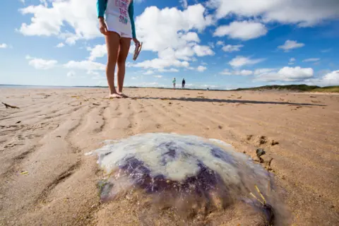
But it may be disrupting species’ breeding patterns and could bring an influx of jellyfish that like warmer waters, including the huge barrel jellyfish, to seas and beaches.
It could also cause harmful algae to grow out of control, creating wide patches of green algae that can poison other life.
 Getty Images
Previous heatwaves have caused harmful blooms of algae and in 2018 caused mass mortality among mussels.
In 2023, jellyfish sightings increased by 32% following a marine heatwave with temperatures 3-4C above average.
The heat could also encourage different fish to move into UK waters, including the bluefin tuna, potentially increasing the amount of fish to catch.
Normally marine heatwaves last around two weeks, so scientists are surprised at how long this one is persisting.
“It is exceptional. We are about two and half months in, which is very long,” says Dr Barthou.
Higher sea temperatures can push up land temperatures too, as sea breezes carry the heat off the ocean.
That happened in May 2024 when a short marine heatwave contributed “significantly” to above-average land temperatures, according to the Met Office.
In some parts of the world – including Australia, the US and the Pacific – marine heatwaves can destroy coral reefs or local fisheries, as well as vital seagrass meadows.
The UK is usually more protected from these impacts because overall the waters are cooler. But scientists still don’t know very much about them and have a lot more to discover.
A recent study led by Dr Jacobs found that the UK hotspots are the southern North Sea and the English channel, where heatwaves can last longer than other areas of the country.
Oceans have absorbed 90% of the excess heat created by humans burning fossil fuels, and as a result have warmed overall by 1C.
“Before we started having this exceptional weather this spring, the waters were already in a hotter state,” says Dr Barthou.
In the North Atlantic, sea surface temperatures have been increasing by around 0.3C per decade over the last 40 years, according to the Met Office.
The long spell of warm, dry weather is expected to break slightly this weekend.
“The ocean lags behind the atmosphere by at least a few days, so it might be that into next week we might start to see the ocean cooling off,” says Dr Jacobs.
But she says that this might be just a “temporary dip” as the longer-range forecast suggests the weather will warm up again.
Graphics by Erwan Rivault